Hayli Gubbi Volcano Eruption: A Major Geological Event
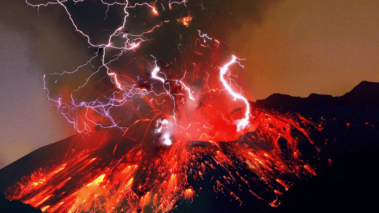
Ethiopia's Hayli Gubbi volcano, located in the Afar region approximately 800 km northeast of Addis Ababa, erupted on November 23, 2025, marking its first recorded eruption in approximately 12,000 years. The massive eruption sent an ash plume rising to approximately 15-16 km (45,000 feet) into the atmosphere, splitting into two distinct trajectories—one drifting northeast and another moving northwest. The volcanic ash cloud traveled across the Red Sea into Yemen, Oman, and reached as far as western India, causing significant disruptions to aviation across multiple countries.
Ethiopian volcano erupts after 12,000 years: What we know
The eruption occurred around 11:30 AM local time (08:30 GMT) and was classified as a sub-Plinian eruption, characterized by a strong vertical ash column and widespread dispersal. Residents in the neighboring village of Afdera were blanketed in ash, though no injuries or fatalities were reported.
Understanding the East African Rift System
Hayli Gubbi is situated within the Afar Depression, one of the most tectonically active rift zones on Earth. This region is part of the broader East African Rift System (EARS), where three major tectonic plates are actively diverging:
Arabian Plate
Nubian (African) Plate
Somali Plate
East African Rift – Geology In
Key Geological Features of the Afar Region
The Afar Triple Junction represents a classic example of continental rifting leading to seafloor spreading. This geological setting creates ideal conditions for volcanic activity due to:
Divergent plate boundary causing crustal thinning
Afar Mantle Plume providing heat and magma supply
Fissure eruptions releasing large volumes of basaltic lava
Frequent seismic activity linked to the continental rifting process
Hayli Gubbi is a shield volcano, characterized by its broad, gently sloping structure formed by highly fluid basaltic lava. It is part of the Erta Ale volcanic range, which includes Ethiopia's most continuously active volcano, Erta Ale.
Global Volcano Statistics: Key Facts for Competitive Exams
Understanding global volcanism is crucial for geography sections in UPSC and other competitive examinations.
| Parameter | Data |
|---|---|
| Total potentially active volcanoes worldwide | ~1,350 |
| Volcanoes in Pacific Ring of Fire | ~75% of world's total |
| Active volcanoes in Indonesia | 127+ (highest concentration) |
| Annual volcanic eruptions globally | 40-60 eruptions per year |
| Continuing eruptions (Sept 2025) | 44 volcanoes worldwide |
| Confirmed eruptions in 2025 | 63 eruptions from 58 volcanoes |
The Pacific Ring of Fire: Earth's Most Volcanic Region
The Pacific Ring of Fire is a 25,000-mile (40,000 km) horseshoe-shaped belt encircling the Pacific Ocean, hosting approximately 75% of the world's active and dormant volcanoes and 90% of global earthquakes.
Ring of Fire | Definition, Map, & Facts | Britannica
This region formed due to subduction zones where oceanic plates dive beneath continental plates, causing intense pressure, friction, and magma formation that leads to volcanic activity. Countries with the highest volcanic concentrations include:
United States: 165 Holocene volcanoes
Japan: 120 volcanoes
Russia: 114 volcanoes
Indonesia: 107+ volcanoes
Chile: 90 volcanoes
India's Only Active Volcano: Barren Island
Barren Island, located approximately 140 km east of Port Blair in the Andaman and Nicobar Islands, is India's only confirmed active volcano and South Asia's only active volcanic site.
Key Facts About Barren Island Volcano
| Characteristic | Details |
|---|---|
| Location | Andaman Sea, 140 km NE of Port Blair |
| Height | 354 meters above sea level |
| Area | ~8.3 sq km (circular island) |
| First recorded eruption | 1787 |
| Tectonic setting | Indian Plate meets Burma (Myanmar) Microplate |
| Status | Uninhabited |
Recent Activity (2025)
Barren Island witnessed two minor eruptions in September 2025—on September 13 and September 20. The September 20 eruption was preceded by a magnitude 4.2 earthquake two days earlier. On October 2, 2025, explosive activity was reported with an ash plume rising to approximately 10,000 feet. Scientists attribute the volcano's activity purely to magmatic processes, with the magma chamber located 18-20 km deep.
Historical Perspective: Mount Tambora and the Year Without a Summer
The 1815 eruption of Mount Tambora in Indonesia remains the largest observed volcanic eruption in recorded history, measuring 7 on the Volcanic Explosivity Index (VEI).
Impact of the Tambora Eruption
The eruption ejected approximately 24 cubic miles (100 cubic km) of ash, pumice, and aerosols along with 60 megatons of sulfur into the atmosphere. This massive volcanic material blocked sunlight, causing global temperatures to drop by 3°C (5.4°F).
The year 1816 became known as the "Year Without a Summer" due to:
Unseasonably cold weather across the Northern Hemisphere
Snowstorms in June and frosts in July
Severe agricultural failures and food shortages
Over 100,000 deaths due to starvation, disease, and unrest
This event demonstrates how volcanic activity can have lasting global impacts on climate and society—a concept frequently tested in environmental science and geography sections of competitive exams.
Types of Volcanoes: Shield vs Stratovolcanoes
Understanding volcano classification is essential for UPSC Prelims and State PCS examinations.
| Feature | Shield Volcano | Stratovolcano (Composite) |
|---|---|---|
| Shape | Broad, gently sloping (shield-like) | Steep-sided, conical |
| Magma type | Basaltic (low silica, fluid) | Andesitic to rhyolitic (high silica, viscous) |
| Eruption style | Effusive, gentle lava flows | Explosive, violent eruptions |
| Example | Hayli Gubbi, Mauna Loa (Hawaii) | Mount Tambora, Mount Fuji |
| Tectonic setting | Divergent boundaries, hotspots | Subduction zones |
Hayli Gubbi exemplifies an unusual case where a shield volcano produced an explosive sub-Plinian eruption due to the presence of more silica-rich magma types like trachyte or rhyolite, which trapped gases and built up pressure.
Why This Matters for Your Exam Preparation
The Hayli Gubbi eruption and related volcanic concepts are highly relevant for UPSC Civil Services, State PCS, SSC, and other competitive examinations across multiple papers:
For UPSC Prelims (General Studies Paper I):
Geography questions on volcanism, plate tectonics, and the East African Rift System
Questions on India's volcanic features (Barren Island, Narcondam)
Pacific Ring of Fire and global earthquake-volcano distribution
For UPSC Mains (GS Paper I – Geography):
Geophysical phenomena including volcanism and earthquakes
Tectonic setting and geological processes
Distribution of critical geographical features
Key Takeaways for Quick Revision:
Hayli Gubbi is a shield volcano in Ethiopia's Afar region that erupted after ~12,000 years on November 23, 2025
The eruption occurred at the Afar Triple Junction where three tectonic plates (Arabian, Nubian, Somali) are diverging
India has only one active volcano—Barren Island in Andaman & Nicobar
75% of world's active volcanoes are located in the Pacific Ring of Fire
Mount Tambora's 1815 eruption caused the "Year Without a Summer" (1816)
Global count: approximately 1,350 potentially active volcanoes worldwide
Stay updated with daily current affairs at Atharva Examwise for comprehensive UPSC and competitive exam preparation.