
UPSC Current Affairs: Indian Standard Time, Chai Bagan Time, and the Dual Time Zone Debate
The longitudinal geometry of the Indian landmass spans nearly thirty degrees, generating a solar time differential of approximately two hours between the eastern peaks of Arunachal Pradesh and the western coastline of Gujarat. While the Republic of India has maintained a unified time convention—Indian Standard Time (IST)—since independence, persistent structural asymmetries in daylight utilization, labor productivity, and public health have sustained an ongoing debate over administrative time zoning.
Understanding the historical evolution, physical geography, metrological frameworks, and governance implications of standard time is essential for candidates preparing for the civil services and allied competitive examinations.
Historical Genesis of Standardized Time in India
The development of standardized temporal administration across the subcontinent was shaped by the expansion of colonial rail networks, maritime trade corridors, and telegraphic infrastructure.
Pre-Independence Plurality and the Meridian of 1884
Prior to national standardization, municipal and commercial centers operated on independent solar times. Following the International Meridian Conference of 1884, British India established two primary regional time zones: Bombay Time ($\text{UTC}+04:51$) and Calcutta Time ($\text{UTC}+05:53:20$). Simultaneously, the Madras Observatory established Madras Time, which the railway administration utilized as an operational standard to prevent single-track scheduling collisions.
In 1906, the colonial government designated a unified standard meridian along the $82.5^\circ\text{ E}$ ($82^\circ 30'\text{ E}$) longitude. However, regional municipal corporations and mercantile communities resisted complete synchronization, retaining their local solar conventions for decades.
Post-Independence Unification and Municipal Resistance
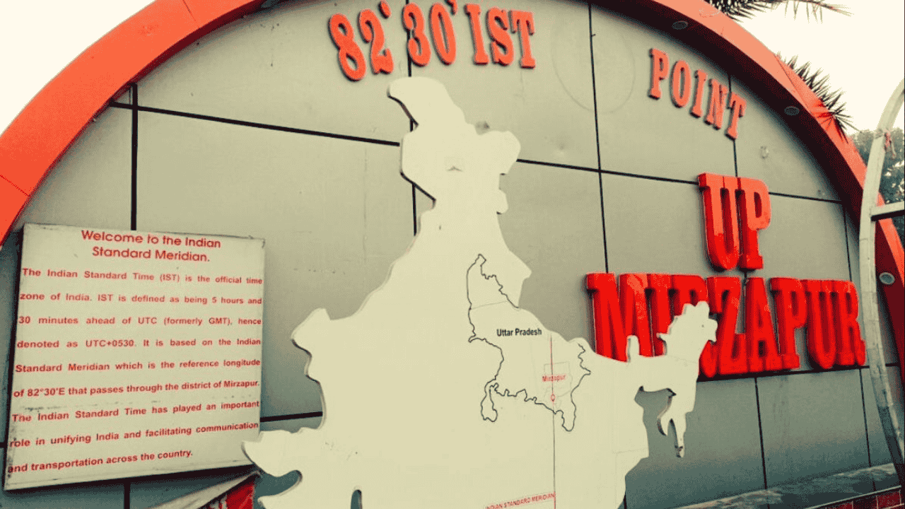
On September 1, 1947, approximately two weeks after political independence, Indian Standard Time was established as the official standard time for the sovereign nation. The reference axis was fixed along the $82^\circ 30'\text{ E}$ meridian passing near Mirzapur, Uttar Pradesh, setting the national standard exactly 5 hours and 30 minutes ahead of Greenwich Mean Time ($\text{UTC}+05:30$).
The transition to a single standard encountered varied regional responses. While the Calcutta municipal jurisdiction relinquished its local time in 1948, the Municipal Corporation of Bombay retained Bombay Time until 1955, underscoring the deep integration of local solar rhythms with urban commercial life.
The Standard Meridian of India ($82^\circ 30'\text{ E}$) intersects five states in a north-to-south orientation:
Uttar Pradesh
Madhya Pradesh
Chhattisgarh
Odisha
Andhra Pradesh
Aspirants can examine the spatial dynamics of Indian physiography through the Atharva Examwise Physical Geography Comprehensive Guide.
Geographic Realities and Informal Daylight Adaptations
The longitudinal extremities of mainland India extend from $68^\circ 7'\text{ E}$ at Ghuar Mota in the Kutch district of Gujarat to $97^\circ 25'\text{ E}$ at Dong in the Anjaw district of Arunachal Pradesh. This longitudinal distance of $29^\circ 18'$ translates directly into an astronomical solar variance of approximately 116 minutes.
| Geographic Parameter | Western Extremity (Ghuar Mota, Gujarat) | Reference Meridian (Mirzapur, Uttar Pradesh) | Eastern Extremity (Dong, Arunachal Pradesh) |
|---|---|---|---|
| Longitudinal Coordinate | $68^\circ 7'\text{ E}$ [cite: 1, 2] | $82^\circ 30'\text{ E}$ [cite: 1, 2] | $97^\circ 25'\text{ E}$ [cite: 1, 2] |
| Local Solar Offset | $\approx\text{UTC}+04:32$ | $\text{UTC}+05:30$ [cite: 1, 2] | $\approx\text{UTC}+06:30$ [cite: 3, 10] |
| Circadian Suitability of IST | Highly Suitable | Manageable | Highly Unsuitable |
| Solar Noon Characteristics | Retarded relative to official clock | Aligned with standard clock | Advanced relative to official clock |
The Tradition of Chai Bagan Time
To accommodate the early sunrise in the eastern quadrant, tea plantations across Assam instituted an informal operating system known as Chai Bagan Time or Bagan Time during the colonial period. Operating exactly one hour ahead of IST ($\text{UTC}+06:30$), this arrangement advances the working schedule to synchronize agricultural labor with peak daylight.
Field laborers begin work between 06:00 and 07:00 IST (07:00 to 08:00 Bagan Time) and complete shifts prior to the early afternoon dusk. Although Chai Bagan Time remains an informal system lacking statutory backing, it highlights the practical limitations of administering a single standard time across broad longitudinal spans.
Metrological Precision and the CSIR-NPL Dual Time Zone Proposal
The statutory authority for timekeeping in India rests with the Council of Scientific & Industrial Research–National Physical Laboratory (CSIR-NPL) in New Delhi. As the National Metrology Institute (NMI), CSIR-NPL generates and disseminates the Primary Timescale $\text{UTC}(\text{NPLI})$, maintained via an ensemble of high-precision cesium atomic clocks and hydrogen masers. This system operates with an uncertainty of $\pm 2.8$ nanoseconds relative to Coordinated Universal Time (UTC) at the International Bureau of Weights and Measures (BIPM) in Sèvres, France.
In a landmark research study published in the peer-reviewed journal Current Science, CSIR-NPL researchers formally established the technical framework for implementing two distinct standard times:
IST-I ($\text{UTC}+05:30$): Encompassing the territory between longitudes $68^\circ 7'\text{ E}$ and $89^\circ 52'\text{ E}$, covering central, western, northern, and southern India.
IST-II ($\text{UTC}+06:30$): Encompassing the region between longitudes $89^\circ 52'\text{ E}$ and $97^\circ 25'\text{ E}$, comprising the eight states of the Northeast (Assam, Arunachal Pradesh, Meghalaya, Nagaland, Manipur, Mizoram, Tripura, and Sikkim) along with the Union Territory of Andaman and Nicobar Islands.
The operational feasibility of the CSIR-NPL proposal relies on setting the spatial boundary at the physical junction between West Bengal and Assam at $89^\circ 52'\text{ E}$. Because rail transport infrastructure across this corridor narrows through the Siliguri Corridor, transit time reconciliation would be restricted to two specific rail junctions: New Cooch Behar and Alipurduar. Restricting time transitions to these two points substantially reduces operational hazards associated with non-automated railway signaling systems.
Further coverage of atomic timekeeping and national metrological architecture can be accessed at the Atharva Examwise Science and Technology Portal.
Policy Trade-Offs: Socio-Economic Gains vs. Administrative Complexities
The decision to transition from a unified temporal regime to a dual system involves complex trade-offs between biological optimization and administrative coordination.
Circadian Rhythm and Cognitive Efficiency
Human metabolic and neurological cycles are regulated by circadian biology, which depends on ambient blue-spectrum sunlight to calibrate the suprachiasmatic nucleus and moderate melatonin secretion. In northeastern India, summer sunrise occurs as early as 04:00 IST, yet commercial establishments, educational institutions, and government offices operate on standard 09:00 or 10:00 IST schedules.
By the time institutional work hours end, early sunset (often before 16:30 IST during winter) triggers melatonin synthesis, leading to elevated fatigue, diminished cognitive throughput, and reduced aggregate productivity. CSIR-NPL analysis demonstrates that while IST is well-aligned with biological rhythms in western zones like Ghuar Mota and southern hubs like Kanyakumari, it remains systematically misaligned with human physiological cycles in Dong and Port Blair.
Macroeconomic and Environmental Dividends
Advancing the clock in eastern territories shifts daily commercial activities into natural daylight hours, reducing dependent evening electricity loads.
Energy Savings: CSIR-NPL models project an annual electricity reduction of approximately 20 million kWh in the northeastern region alone, while broader economic studies estimate nationwide savings of up to 2.7 billion units if daylight is optimized across sectors.
Fiscal and Carbon Reductions: Conserving peak-load electricity yields an estimated annual economic benefit of ₹1,000 crore, while directly lowering fossil-fuel generation and assisting India's Nationally Determined Contributions (NDCs) under climate treaties.
Governance, Logistics, and Security Impediments
Despite technical and physiological merits, dual time zones present several administrative challenges:
Transport Logistics: India's extensive railway network relies partially on manual signaling interventions along regional routes. Dual time zones could introduce human scheduling errors at zonal crossover points unless inter-zonal signaling is fully automated.
Financial and Administrative Coordination: Differing business hours between national administrative centers in New Delhi or financial markets in Mumbai and eastern regional offices could reduce overlapping transaction windows, affecting commercial banking, judicial proceedings, and real-time settlement mechanisms.
Metrological Redundancy: Implementing IST-II requires CSIR-NPL to establish an accredited secondary primary-time laboratory in the Northeast equipped with atomic references synchronized directly with the BIPM.
Social and Political Dynamics: Concerns have been raised in policy circles that establishing a separate temporal identity for the Northeast could accentuate perceptions of spatial and administrative detachment from the national mainland.
Strategic Alternatives to Dual Time Zoning
Policymakers have evaluated non-structural interventions that secure the benefits of daylight optimization without altering standard meridians:
Daylight Saving Time (DST): Seasonally advancing clocks by one hour across the entire nation during summer months. However, India's tropical latitude produces minimal variation in seasonal daylight duration across southern and peninsular states, making nationwide DST less suitable than in higher-latitude countries.
Administrative Flexitime and Staggered Shifts: Empowering state governments in the Northeast to advance local public office and educational schedules (e.g., establishing 08:00 to 16:00 working hours) under existing central provisions, while preserving a uniform IST for national banking, civil aviation, telecommunications, and defense logistics.
Single IST versus Proposed Dual Time Zones
| Assessment Parameter | Single Time Zone (Current IST) | Dual Time Zones (Proposed IST-I & IST-II) |
|---|---|---|
| Reference Coordinates | $82^\circ 30'\text{ E}$ passing through Mirzapur, UP | IST-I: $82^\circ 30'\text{ E}$; IST-II: Demarcation at $89^\circ 52'\text{ E}$ [cite: 2, 3, 10] |
| UTC Offset Values | $\text{UTC}+05:30$ uniformly across the territory | IST-I: $\text{UTC}+05:30$; IST-II: $\text{UTC}+06:30$ [cite: 2, 3, 10] |
| Geographic Scope | All 28 States and 8 Union Territories | IST-I: Rest of India; IST-II: 8 NE States & A&N Islands |
| Physiological Impact | Causes biological desynchronization in the East | Restores circadian alignment across all longitudes |
| Power Sector Impact | High evening domestic peak load in eastern states | Projected saving of 20M kWh to 2.7B kWh annually |
| Transit Scheduling | Unified operational timetable nationwide | Requires time resets at New Cooch Behar & Alipurduar |
| Metrological Base | Central atomic ensemble at CSIR-NPL, New Delhi | Primary atomic scale in Delhi plus secondary NE facility |
Why this matters for your exam preparation
The debate surrounding standard time zones in India connects physical geography, constitutional governance, national infrastructure, and public health, making it highly relevant across multiple stages of competitive examinations.
UPSC Civil Services Examination (CSE)
General Studies Paper I (Indian Geography & Society):
Spatial analysis of longitudinal extent ($68^\circ 7'\text{ E}$ to $97^\circ 25'\text{ E}$) and standard solar calculations.
Identification of the five states intersected by the $82^\circ 30'\text{ E}$ meridian (UP, MP, Chhattisgarh, Odisha, Andhra Pradesh).
Cultural and economic history of colonial-era labour practices, including Assam's Chai Bagan Time.
General Studies Paper II (Polity, Governance & Federalism):
Administrative relations between the Union and Northeastern states regarding regional public administration.
National integration considerations within regional administrative decentralization policies.
General Studies Paper III (Economy, Infrastructure & Metrology):
Energy conservation economics, peak-load power management, and grid stability dividends.
The role of national scientific institutions like the Council of Scientific & Industrial Research–National Physical Laboratory (CSIR-NPL) in maintaining national standard infrastructure ($\text{UTC}(\text{NPLI})$, cesium atomic clocks, hydrogen masers, and BIPM traceability).
Railway signaling logistics and transport management systems.
State Public Service Commissions (APSC, UPPSC, BPSC, WBPSC)
Assam Public Service Commission (APSC): Local economic productivity, historical adoption of Chai Bagan Time in tea estates, and regional development strategies.
Uttar Pradesh Public Service Commission (UPPSC): Geographic and astronomical significance of Mirzapur as the reference meridian for IST.
West Bengal Public Service Commission (WBPSC): Cross-border transit mechanics at New Cooch Behar and Alipurduar junctions.
For structured test series and answer-writing practice on these subjects, refer to the Atharva Examwise GS Mains Answer Writing Program.