
UPSC Current Affairs: Greater Male Connectivity Project and India-Maldives Strategic Relations | Atharva Examwise Current News
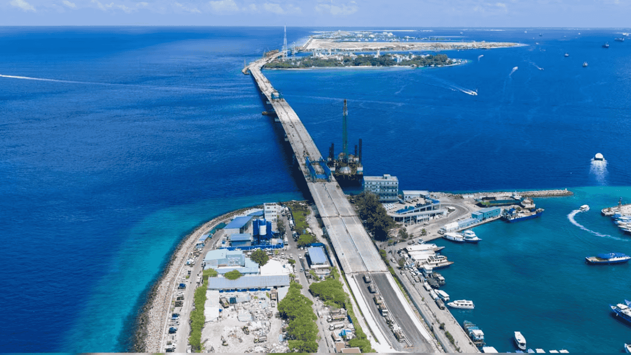
The Greater Malé Connectivity Project (GMCP), widely known as the Thilamalé Bridge, has reached an operational milestone with the successful installation of the final precast superstructure segment connecting the Maldivian capital of Malé to the island of Villingili. Executed by the Indian engineering and infrastructure firm Afcons Infrastructure, the development marks the advancement of the largest civil infrastructure initiative ever undertaken in the Republic of Maldives. With cumulative progress surpassing 75%, this 6.74-kilometer multimodal bridge and causeway network represents a physical and institutional anchor of India’s foreign policy framework in the Indian Ocean Region (IOR).
Strategic Overview and Project Genesis
The geographic concentration of economic activity and population within the Maldivian archipelago has historically created acute logistical and developmental bottlenecks. The capital island of Malé houses nearly 40% of the national population on a land area of just over eight square kilometers. To alleviate structural congestion, enhance inter-island economic mobility, and establish an integrated urban corridor, the GMCP was formally conceptualized during the administration of former President Ibrahim Mohamed Solih.
The bilateral implementation agreement was finalized on August 26, 2021, when the Maldivian government awarded the construction contract to Afcons Infrastructure. The project establishes a continuous overland transport corridor linking four central islands: the political capital of Malé, the residential island of Villingili, the designated commercial port hub of Gulhifalhu, and the industrial zone of Thilafushi. This connectivity framework builds upon prior developmental collaborations executed by Indian enterprises in the archipelago, such as the Addu City Development Project in the southern atolls, which delivered 111 kilometers of arterial roads, ocean detour bridges, and flood mitigation drainage infrastructure.
Engineering Profile and Structural Innovations
Constructing an inter-island maritime corridor across deep channels subject to severe hydrodynamic stresses required specialized marine civil engineering adaptations. The GMCP integrates deep-sea viaducts, marine navigation spans, and heavy precast components to maintain navigational clearances for commercial sea routes while minimizing ecological disruption to delicate coral reef ecosystems.
| Technical Parameter | Engineering Specification | Strategic and Operational Relevance |
|---|---|---|
| Total Corridor Length | 6.74 kilometers | Links Malé, Villingili, Gulhifalhu, and Thilafushi across open-sea channels. |
| Navigation Bridges | 3 main spans of 140 meters each | Accommodates uninterrupted maritime transit for regional and international shipping. |
| Substructure Foundations | 264 piles across 68 marine and terrestrial locations | Comprises 75 deep-marine piles, 85 shallow-water piles, and 104 land piles. |
| Maximum Foundation Depth | 120 meters below sea level | Represents one of the deepest recorded marine bridge foundation installations globally. |
| Superstructure Segment Dimensions | Height: 8.177 m to 8.32 m; Width: 25.37 m | World-record height for precast navigation span box-girder segments. |
| Precast Unit Displacement | 216.04 to 240 metric tonnes | Fabricated off-site to accelerate marine assembly and reduce local environmental impact. |
| Component Bridge Corridors | 3 contiguous marine links | Malé–Villingili, Villingili–Gulhifalhu, and Gulhifalhu–Thilafushi. |
The fabrication and placement of the 8.177-to-8.32-meter precast segments represent an engineering milestone for Indian infrastructure execution overseas. By completing deep foundation piling under complex geotechnical conditions and installing heavy precast navigation segments, the project establishes a reference standard for regional marine infrastructure.
Financial Architecture and Bilateral Funding Mechanism
The GMCP is financed through a dedicated bilateral economic cooperation model totaling approximately USD 500 million (approximately ₹4,350 crore):
Grant Component: A non-reimbursable budgetary grant of USD 100 million provided directly by the Government of India.
Concessional Line of Credit (LoC): A USD 400 million sovereign Line of Credit extended through the Export-Import Bank of India (EXIM Bank) on concessional repayment terms.
This financial framework exemplifies New Delhi’s structured approach to sovereign developmental assistance. Unlike commercial debt models that can lead to acute balance-of-payments stress in small island developing states (SIDS), India’s development assistance blends direct grant support with long-tenor, low-interest credit lines. This ensures fiscal sustainability while prioritizing asset creation that generates positive domestic economic externalities.
Geopolitical Imperatives: India-Maldives Strategic Matrix
The progression of the GMCP serves vital geopolitical, geo-economic, and maritime security objectives within India’s broader foreign policy architecture in the central Indian Ocean.
Operationalization of Neighbourhood First and Vision MAHASAGAR
The Republic of Maldives sits at the geographical intersection of vital international Sea Lines of Communication (SLOCs), particularly the Eight Degree and One and a Half Degree channels, through which major global containerized freight and energy shipments transit. New Delhi views Malé as a cornerstone partner under its Neighbourhood First policy and Vision MAHASAGAR (Mutual and Holistic Advancement for Security and Growth Across Regions). The GMCP functions as the flagship physical manifestation of this doctrine, demonstrating India’s capacity to deliver complex infrastructure that directly supports the host nation's economic autonomy.
Regional Strategic Balance in South Asia
The GMCP also serves as a strategic counterweight to competing regional infrastructure diplomacy, most notably the 2.1-kilometer Sinamalé Bridge (China-Maldives Friendship Bridge) constructed under Beijing’s Belt and Road Initiative (BRI). At more than three times the length and scale of the Sinamalé Bridge, the GMCP highlights the capacity of Indian public and private engineering consortiums to undertake transformational projects in the littoral states of South Asia.
Integrated Maritime Supply Chains
The bridge works alongside broader bilateral supply chain integration. In September 2020, India operationalized a direct cargo ferry service linking the South Indian ports of Tuticorin and Kochi with the Maldivian ports of Malé and Kulhudhuffushi. The physical integration of Malé with industrial and port islands enhances the economic viability of these direct shipping corridors, insulating the island nation from external supply disruptions and lowering the landed cost of basic commodities.
Socio-Economic Ramifications for the Maldivian Economy
The physical unification of the four central atoll islands provides essential structural and economic benefits:
Urban Decongestion: Enables the systematic relocation of government housing, residential zones, and administrative infrastructure from Malé to Villingili and Gulhifalhu.
Port Modernization and Logistics Integration: Facilitates the relocation of the congested Malé commercial port to the dedicated international deep-water port at Gulhifalhu, reducing vessel turnaround times and demurrage costs.
Industrial Centralization and Waste Processing: Connects the heavy industrial zone and waste-processing infrastructure of Thilafushi directly to the capital by road, lowering freight costs and eliminating intermediate sea-barging bottlenecks.
Macroeconomic Diversification: Stimulates private sector investment in logistics, light manufacturing, and construction, broadening the Maldivian revenue base beyond its primary exposure to international tourism.
Why this matters for your exam preparation
For candidates preparing for the UPSC Civil Services Examination and state public service commissions, the Greater Malé Connectivity Project intersects across several dimensions of the syllabus:
General Studies Paper II: International Relations and Bilateral Ties
Neighbourhood Diplomacy: Illustrates the shift in Indian foreign policy from diplomatic commitments to high-impact physical asset delivery within the immediate neighbourhood. Aspirants should review foundational doctrines via the Atharva Examwise India-Maldives Strategic Relations Analysis.
Regional Maritime Frameworks: Connects bilateral infrastructure initiatives to overarching maritime frameworks, including SAGAR (Security and Growth for All in the Region), Vision MAHASAGAR, the Colombo Security Conclave (CSC), and the Indian Ocean Rim Association (IORA).
Development Cooperation Paradigms: Provides a structured case study on India’s development assistance model (grant-blended Lines of Credit) versus commercial lending frameworks in developing maritime states.
General Studies Paper III: Infrastructure, Economic Diplomacy, and Security
Cross-Border Infrastructure Financing: Evaluates the role of institutions like EXIM Bank of India and specialized engineering contractors (such as Afcons Infrastructure) in projecting economic capabilities abroad. Detailed financial mechanisms can be explored further in the Atharva Examwise Infrastructure and Sovereign Financing Guide.
SLOC Security and Maritime Logistics: Analyzes how port modernizations and coastal connectivity networks along the Eight Degree Channel reinforce India's maritime domain awareness and logistics resilience.
Civil Services Preliminary Examination: High-Yield Reference Points
Geographical Mapping: Spatial layout of Maldivian atolls and islands, including Malé, Villingili, Gulhifalhu, Thilafushi, and Kulhudhuffushi, alongside key maritime channels (Eight Degree Channel separating Minicoy and the Maldives).
Key Financial Figures: The USD 500 million package (USD 100M Grant + USD 400M LoC) managed under Indian development assistance.
Institutional Execution: Afcons Infrastructure’s role, record-breaking precast segment dimensions (8.177–8.32 meters high), and maritime piling depths reaching 120 meters.
Essay and Analytical Value-Addition
Candidates can utilize the GMCP to demonstrate how physical infrastructure diplomacy reinforces sovereign trust, counters unilateral encirclement strategies, and drives mutual economic advancement among developing littoral nations in the Indo-Pacific.