The NASA-ISRO Synthetic Aperture Radar (NISAR) mission is a historic achievement in international space cooperation and Earth observation technology. Scheduled for launch in June 2025, this $1.5 billion joint venture between the United States and India marks a new chapter in collaboration, set to completely transform how we monitor Earth’s changing climate, natural disasters, and environmental processes. For UPSC and competitive exam aspirants, this mission is a powerful example of growing space diplomacy, technological cooperation, and the increasing importance of climate monitoring.
Mission Overview and Strategic Importance
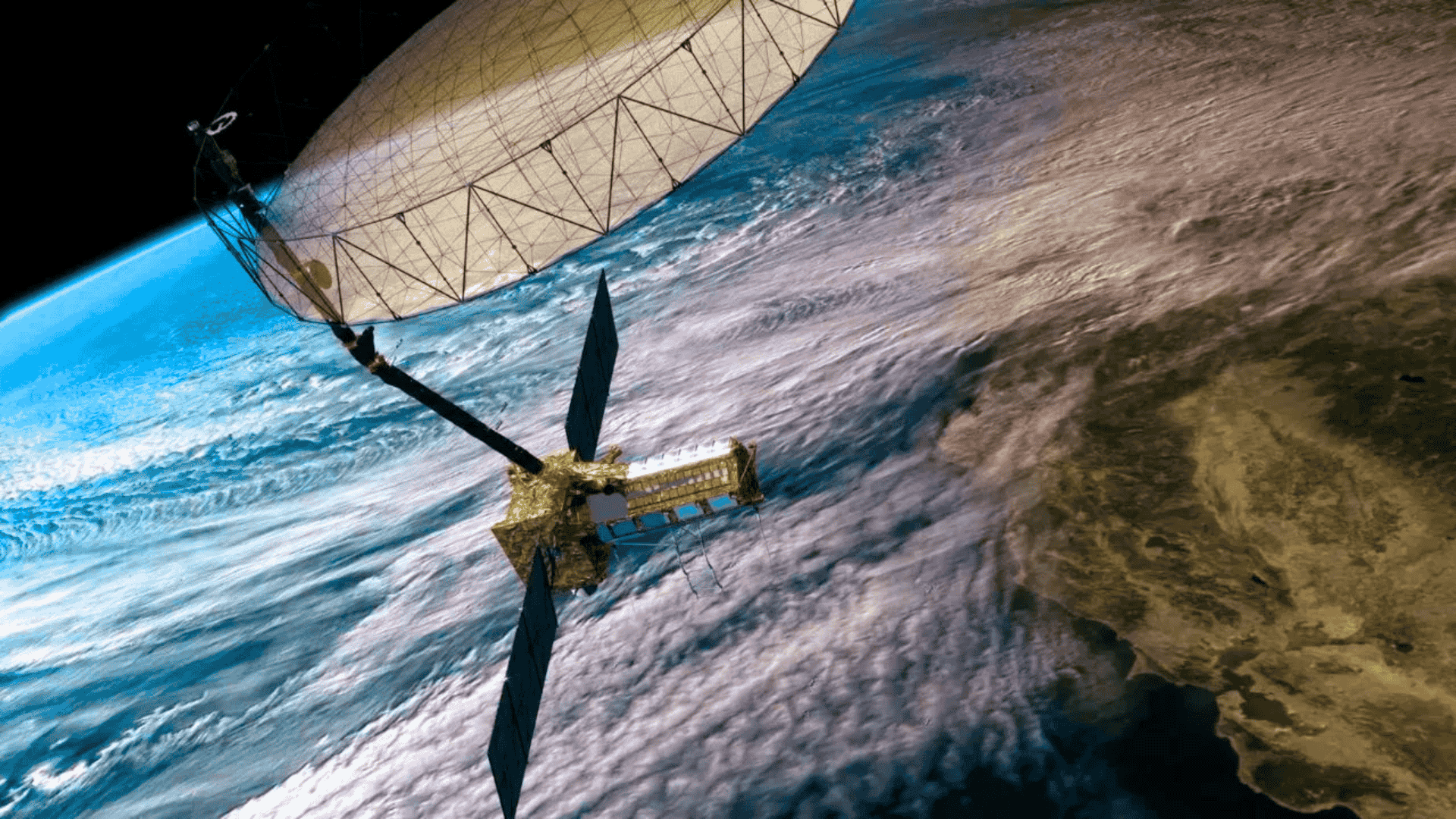
NISAR is the first Earth observation satellite to use dual-frequency synthetic aperture radar technology, combining NASA’s L-band radar and ISRO’s S-band radar. This technology gives the satellite unprecedented capability to monitor the Earth’s surface through clouds, dense vegetation, and both day and night—something traditional optical satellites cannot do.
The mission will map the entire surface of the Earth twice every 12 days. The satellite will operate in a sun-synchronous polar orbit at an altitude of 747 kilometers, with position control within 500 meters and pointing accuracy of less than 273 arcseconds. This technical precision enables detection of changes on the surface at the millimeter level, which is invaluable for monitoring seismic activity, volcanic eruptions, and infrastructure stability.
Key Technical Features
Orbit Parameters: 747 km altitude, 98.4° inclination, 12-day repeat cycle
Radar Systems: L-band (24 cm wavelength) and S-band (9 cm wavelength)
Swath Width: 240 km (SweepSAR technology)
Resolution: 3–10 meters (depending on observation mode)
Data Volume: About 85 terabytes per day
Mission Duration: 3 years (5 years of consumables available)
India-US Space Cooperation Framework
The NISAR partnership, formalized in 2014, is the first major space hardware collaboration between NASA and ISRO. This cooperation demonstrates changing geopolitical relationships and India’s rise as a space power. Under this partnership, NASA provides the L-band SAR system, GPS receivers, high-capacity data recording systems, and telecommunications subsystems, while ISRO is responsible for the S-band SAR, spacecraft bus, launch vehicle, and mission operations.
The cost-sharing arrangement shows the scale of this cooperation: NASA’s contribution is about $1.118 billion and ISRO’s share is about ₹788 crore (about $93 million). This combines India’s cost-effective space capabilities with American technological expertise. The mission’s open data policy will make all scientific data freely available globally within 1–2 days, supporting international climate research and disaster management.
Scientific Objectives and Applications
NISAR addresses four major scientific areas aligned with global climate monitoring and disaster preparedness priorities. Its comprehensive Earth observation capabilities are significant in the following fields:
Climate and Cryosphere Monitoring
This satellite will provide crucial data on ice sheet dynamics, glacier movement, and sea ice characteristics, which are essential for sea-level rise projections. This is especially important for India, as the status of Himalayan glaciers affects the country’s major rivers and agricultural regions.
Ecosystem and Carbon Cycle Analysis
NISAR’s ability to see beneath vegetation enables detailed monitoring of biomass changes, deforestation, and ecosystem disturbances. The L-band radar can detect changes even under dense forests, making it possible to monitor carbon storage and habitat changes.
Natural Disaster Assessment
The mission’s interferometric capabilities allow precise measurement of crustal deformation related to earthquakes, volcanoes, and landslides. This real-time monitoring is valuable for disaster preparedness and risk assessment in seismically sensitive regions like India’s northeast and the Himalayas.
Launch Timeline and Current Status
Due to some technical challenges, especially with the 12-meter deployable antenna reflector system, NISAR’s launch was postponed several times. Now, the satellite is ready for launch in June 2025. It will be launched by ISRO’s GSLV Mark II rocket (GSLV-F16) from the Satish Dhawan Space Centre in Sriharikota.
Since NISAR’s 2,800 kg mass exceeds the capacity of PSLV, GSLV was chosen. Although GSLV’s success rate has been lower than PSLV’s, recent improvements and the mission’s strategic importance make this choice appropriate.
Currently, the satellite’s final integration and testing are underway at ISRO’s Bengaluru facility. Earlier, the satellite underwent extensive testing at NASA’s Jet Propulsion Laboratory. This mission is the result of over a decade of cooperation between the two space agencies.
Significance for India’s Space Program
NISAR makes India a leader in global Earth observation and climate monitoring, showcasing the country’s technological capabilities in advanced radar systems and spacecraft development. The mission’s success could make India a preferred partner for future international space collaborations, leading to new partnerships and commercial opportunities.
For India’s needs, NISAR will monitor coastal processes, mangrove ecosystems, and shallow bathymetry in Indian waters. The mission will also observe sea ice conditions around India’s Antarctic research stations and help detect marine oil spills. These applications are important for India’s Blue Economy and environmental monitoring.
The mission also highlights India’s growing space industry, combining ISRO’s expertise with private sector capabilities. This technological demonstration could advance India’s position in the global commercial space market.
Global Impact and Data Applications
NISAR’s open data policy will make high-resolution Earth observation data globally accessible, supporting international climate research, disaster management, and environmental monitoring. With 85 terabytes of data daily, the mission will provide scientists, governments, and organizations with unprecedented insights into Earth system dynamics.
The mission’s global coverage and high temporal resolution make it especially useful for monitoring rapidly changing environmental conditions, strengthening international climate agreements and disaster response capabilities.
Why This Matters for Your Exam Preparation
The NISAR mission brings together several important topics for UPSC and competitive exams:
Science & Technology: Understanding radar technology, satellite communication, and Earth observation systems shows awareness of contemporary scientific applications in governance and policy-making.
International Relations: India-US space cooperation is an example of changing diplomatic relations, strategic partnerships, and technology transfer agreements that are reshaping global geopolitics.
Environment & Climate Change: NISAR’s monitoring capabilities directly support climate change assessment, disaster management, and environmental governance—core areas for administrative services.
Economic Geography: The mission’s applications in agriculture monitoring, water resource management, and infrastructure assessment connect space technology to developmental challenges and economic planning.
Current Affairs Integration: Space missions like NISAR are frequently asked in prelims and serve as excellent examples in essay writing and interviews about India’s technological capabilities and international partnerships.
For competitive exam preparation, it is important to understand the mission’s dual-frequency radar technology, the India-US partnership model, and practical applications for climate monitoring and disaster management. This knowledge demonstrates awareness of contemporary technological solutions, which is highly valuable for administrative services.
Internal Links:
UPSC Science & Technology Current Affairs
India-US Relations: Latest Analysis
External References: