
India Installs First Glacial Flood Warning System at Ghepan Lake: UPSC Current Affairs October 24, 2026, Daily GK Update | Atharva Examwise Current News
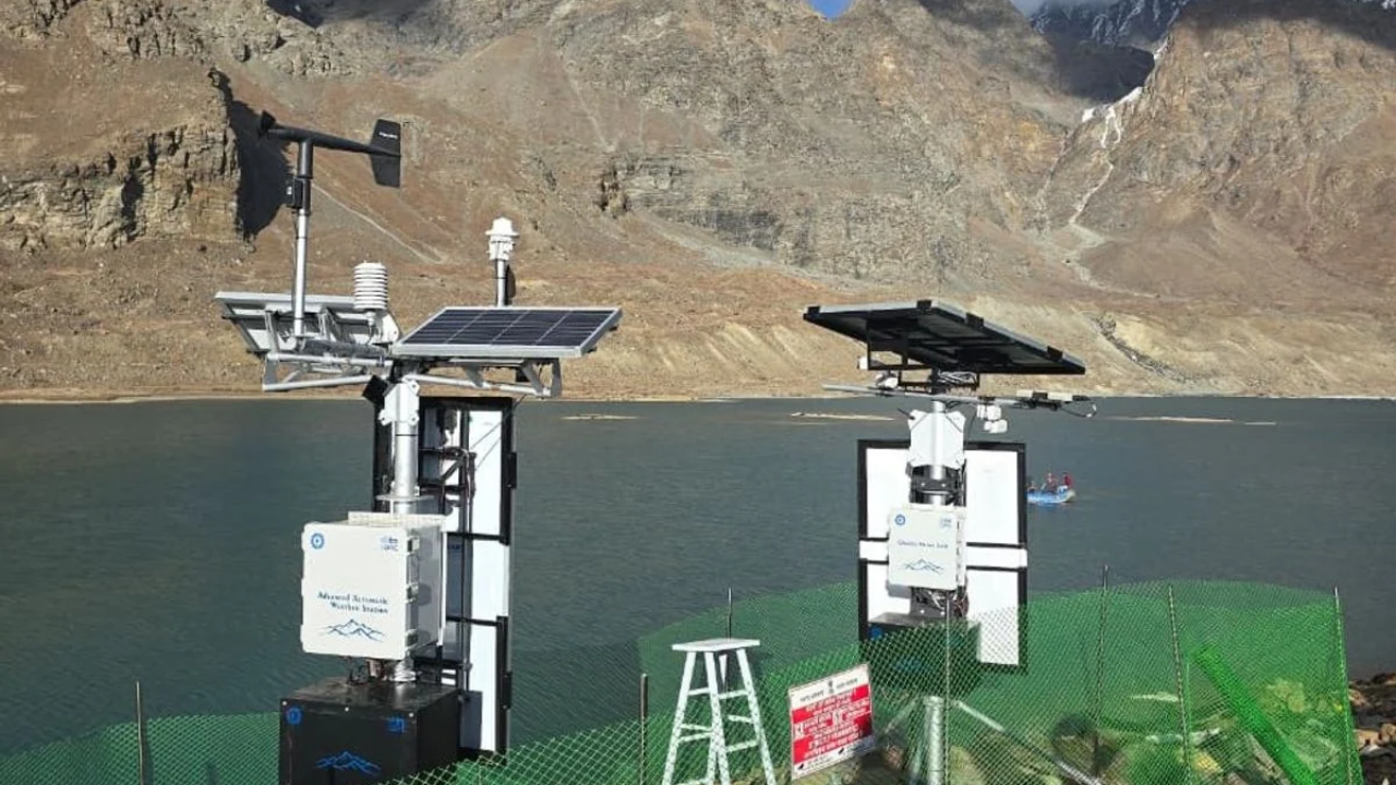
In a pioneering development for high-altitude disaster risk reduction, India has operationalized its first automated Glacial Lake Outburst Flood (GLOF) Early Warning System at the Ghepan Ghat glacial lake in Himachal Pradesh. Perched at an altitude of approximately 4,100 meters above sea level in the ecologically sensitive Lahaul and Spiti district, this system establishes continuous sensory surveillance over an expanding proglacial body that presents severe downstream flood hazards. Developed by the Centre for Development of Advanced Computing (C-DAC) as part of a pilot initiative funded by the National Disaster Management Authority (NDMA), the deployment integrates real-time environmental sensors with high-performance computational modeling.
For aspirants following competitive exam news today, this initiative underscores India's transition from passive satellite surveillance to active, in-situ early warning telemetry. As covered in this Atharva Examwise Current Affairs briefing, the Ghepan Ghat installation provides a prototype for mitigating cryospheric risks across the wider Himalayan river basins.
Geographic and Hydrological Profile of Ghepan Ghat Lake
Ghepan Ghat glacial lake is located in the Lahaul Valley of Himachal Pradesh, situated within the high-relief terrain of the Pir Panjal and Great Himalayan ranges. The lake is impounded by lateral and terminal moraines and is fed by three distinct hanging glaciers melting from the Mount Gipan Go massif. As global temperatures rise, accelerated glacial retreat has steadily enlarged the lake basin, which now holds an estimated 35.08 million cubic meters of meltwater.
The hydrological outflow from Ghepan Ghat drains southwest through the Sissu Nullah, a high-gradient stream that drops sharply before emptying into the Chandra River near Sissu village. Downstream from Sissu, the Chandra River converges with the Bhaga River at Tandi to form the Chandrabhaga, known internationally as the Chenab River—a major transboundary tributary of the Indus River system.
Because the lake is situated directly upstream of Sissu, a sudden failure of the unconsolidated moraine dam would send catastrophic flood waves into the Chandra Valley. Such an outburst threatens rural settlements, riverbed bridges, strategic stretches of National Highway 3, transit portals linked to the Atal Tunnel, and downstream hydroelectric installations across Himachal Pradesh and the Union Territory of Jammu & Kashmir.
Satellite assessments released by the National Remote Sensing Centre (NRSC) of the Indian Space Research Organisation (ISRO) in late 2023 detected substantial volumetric and spatial expansion of the lake, establishing Ghepan Ghat as a critically dangerous water body requiring automated, on-site monitoring.
| Geographical / Physical Metric | Parameter Detail |
|---|---|
| Geographic Coordinates & District | Lahaul and Spiti District, Himachal Pradesh |
| Lake Altitude | ~4,070 to 4,146 metres above mean sea level |
| Estimated Impounded Water Volume | ~35.08 million cubic metres |
| Glacial Feeding System | Hanging glaciers receding from Mount Gipan Go |
| Immediate Outflow Drainage | Sissu Nullah $\rightarrow$ Chandra River $\rightarrow$ Chenab River Basin |
| Key Downstream Infrastructure at Risk | Sissu settlement, National Highway 3, Atal Tunnel access, Chenab hydro projects |
Key Facts and Exam-Relevant Data
To aid revision for competitive tests and state public service exams, the fundamental facts of the Ghepan Ghat monitoring project include:
Pioneering Milestone: Represents the first operational in-situ GLOF early warning telemetry system installed at a glacial lake in India.
Institutional Architecture: Engineered by the Centre for Development of Advanced Computing (C-DAC) and sponsored as a pilot initiative by the National Disaster Management Authority (NDMA).
Primary Alert Triggers: Configured to detect abrupt lake-level surges, moraine displacement waves, intense precipitation, and thermal spikes that precede glacial breaches.
Energy Autonomy: Equipped with low-temperature chemical battery packs and solar arrays engineered to sustain continuous data transmission for 15 to 20 days under complete cloud cover or blizzard conditions.
ISRO Remote Sensing Precedent: Follows an empirical hazard alert issued by ISRO's National Remote Sensing Centre (NRSC) in November 2023, which documented rapid spatial growth of the lake.
National Policy Linkage: Integrates with the central government's National GLOF Risk Mitigation Programme, which initially evaluated 56 high-risk glacial lakes before expanding to 195 prioritized bodies across Himalayan states.
Technical Architecture and Working of the Early Warning System
High-altitude periglacial environments present severe operational constraints, such as sub-zero temperatures, intense wind shearing, snow avalanches, and persistent cloud cover that limits solar generation. The early warning array engineered by C-DAC counters these conditions through a multi-sensor, fault-tolerant infrastructure designed for unattended high-altitude deployment.
The system tracks parameters through three physical stations:
Floating Lacustrine Monitoring Station: An instrumented, marine-grade buoy anchored within the glacial lake that monitors water column depth, hydrostatic pressure, surface oscillations, and thermal gradients. It detects displacement waves (seiches) triggered by hanging ice or rock masses plunging into the reservoir.
Shore-Based Automatic Weather Station (AWS): Erected on the stable moraine crest, the AWS logs ambient temperature, atmospheric pressure, relative humidity, wind velocity, and liquid precipitation. These observations allow meteorologists to correlate cloudburst events or rapid warming anomalies with accelerated meltwater discharge.
Glacier Vision Monitoring Unit: A weatherized camera mast housing dual high-resolution optical and infrared imaging sensors. The unit captures continuous visual feeds of the lateral moraine flanks, terminal ice cliffs, and natural outlet spillways, providing visual confirmation of slope movement, bank collapse, or debris-dam failure.
Sensor telemetry is routed across satellite channels to C-DAC's high-performance supercomputing infrastructure. The analytical platform processes incoming streams through hydrodynamic simulation models that compute discharge volumes and projected flood wave travel times. When sensor inputs exceed pre-programmed safety thresholds, automated red alerts are transmitted to the Himachal Pradesh State Emergency Operations Centre (SEOC) and the District Disaster Management Authority (DDMA) in Keylong, providing downstream communities and administrative bodies critical lead time to execute evacuation plans.
| Telemetry Component | Hardware Specification | Core Disaster Risk Function |
|---|---|---|
| Lacustrine Buoy Station | Marine-grade floating buoy with anchored mooring lines | Measures real-time water elevation, hydrostatic pressure, and wave surges |
| Automatic Weather Station (AWS) | Ruggedized mast with multi-parameter meteorological sensors | Records sudden temperature spikes, cloudbursts, and barometric anomalies |
| Glacier Vision Unit | Dual optical and thermal infrared camera assembly | Tracks moraine dam stability, ice calving, and channel obstruction |
| Autonomous Power Unit | Cryogenic battery banks coupled to photovoltaic panels | Provides uninterrupted operations for 15–20 days without active sunlight |
| Computing Core | C-DAC high-performance supercomputing analytical nodes | Runs real-time hydrodynamic breach simulations and issues warning alerts |
Geomorphological Drivers of Glacial Lake Outburst Floods
Glacial Lake Outburst Floods represent sudden, high-magnitude hydrological discharges caused by the catastrophic breach of a natural moraine or ice dam. Unlike engineered civil dams constructed with reinforced masonry or concrete cores, moraine dams consist of unconsolidated glacial till, poorly sorted gravels, sand, and boulders deposited along the glacier margins.
Many Himalayan moraines retain relict subterranean ice cores. Under sustained atmospheric warming, these buried ice masses melt, creating internal structural voids that foster piping erosion and induce dam subsidence.
GLOF triggering mechanics are categorized into two primary pathways:
Displacement Waves Induced by Mass Movement: Cirque walls destabilized by permafrost thaw shed massive hanging-ice avalanches or rockslides directly into the impounded lake. The sudden impact generates large displacement waves that overtop the moraine crest, rapidly cutting an incisive breach channel that drains the lake in a matter of hours.
Piping Failures and Hydrostatic Overpressure: Intense summer melt combined with high-altitude cloudbursts rapidly fills the proglacial basin. The resulting hydrostatic pressure exploits structural fissures and unconsolidated sediments within the moraine wall, producing a progressive internal piping collapse that empties the reservoir without surface overtopping.
Himalayan geomorphology elevates these risks. Across High Mountain Asia, temperatures are rising faster than the global mean, causing rapid glacier down-wasting. Long-term satellite tracking conducted by ISRO indicates that out of more than 2,400 glacial lakes identified across the Indian Himalayas, over 670 lakes expanded significantly between 1984 and 2023, with more than 600 doubling in spatial footprint.
Compounding these cryospheric hazards, the Indian Himalayan Region lies within active Seismic Zones IV and V. Ground tremors can shear through moraine dams, destabilize hanging glaciers, and trigger destructive cascades similar to those observed during the 2013 Kedarnath disaster, the 2021 Chamoli flash flood, and the 2023 South Lhonak outburst in Sikkim. For an overview of structural hazard management, explore our study on Landslide and GLOF Mitigation Strategies in India.
Policy and Governance: NDMA Framework and International Commitments
The installation at Ghepan Ghat reflects a broader transformation in India's disaster management strategy, moving from reactive emergency relief toward technology-driven, proactive disaster risk reduction.
In October 2020, the NDMA published statutory guidelines titled Management of Glacial Lake Outburst Floods (GLOFs), outlining institutional protocols for identifying vulnerable lakes, deploying early warning systems, and executing structural interventions such as siphoning, pumping, and controlled spillway excavation.
Following the collapse of the Chungthang Dam along the Teesta River during the South Lhonak GLOF in Sikkim, the Union Government accelerated the implementation of the National GLOF Risk Mitigation Programme with a preliminary financial allocation of approximately $20 million. The program classified 56 glacial lakes as "very high risk" before expanding its scope to cover 195 prioritized lakes across Jammu & Kashmir, Ladakh, Himachal Pradesh, Uttarakhand, and Sikkim, while tracking 2,485 glacial lakes across the Himalayan river basins.
On the international front, this indigenous technology directly advances India's commitments under global disaster governance frameworks:
Sendai Framework for Disaster Risk Reduction (2015–2030): Fulfills Target G, which obligates signatory states to substantially increase the availability of and access to multi-hazard early warning systems and disaster risk assessments by 2030.
United Nations "Early Warnings for All" Initiative: Supports the global drive led by the United Nations and the World Meteorological Organization (WMO) to ensure universal early-warning protection across vulnerable populations, demonstrating scalable, cost-effective methods for remote mountain regions.
Strategic, Infrastructure, and Transboundary Implications
Deploying sensory networks in high-altitude headwaters carries strategic, infrastructure, and diplomatic ramifications:
Safeguarding Strategic Transportation Corridors: Sissu is located near the northern portal of the Atal Tunnel on the Manali-Leh National Highway axis (NH-3). This transport corridor is essential for civilian connectivity and the strategic deployment of Indian armed forces to Ladakh. GLOF surges descending the Sissu Nullah threaten to destroy approach roads, sever communication networks, and isolate the upper Lahaul Valley. Real-time warnings allow transport authorities to close tunnel access and halt vehicular movement along vulnerable riverbanks.
Protecting Downstream Hydropower Assets: Mountain rivers across Himachal Pradesh support extensive cascades of Run-of-the-River (RoR) hydroelectric projects. GLOF floodwaters carry heavy sediment loads, boulders, and gravel that can destroy intake structures and scour hydro-turbine blades. Lead times provided by sensor networks allow plant managers to open reservoir spillway gates, close desilting chambers, and shut down generation sets, preventing multi-million-dollar equipment losses and long-term disruptions to northern India's regional power grid.
Transboundary Water Management: Because the Chandra River forms a primary headwater tributary of the Chenab River, hydrological shocks within this catchment can travel downstream into Jammu & Kashmir and cross international boundaries into Pakistan. Operating early warning arrays helps upstream riparian authorities manage sudden flood pulses, maintain river safety under the Indus Waters Treaty framework, and build scientific baselines for transboundary disaster resilience.
Strengthening Downstream Community Evacuation: Advanced telemetry is only effective if alerts reach downstream populations in time. The Ghepan Ghat project couples sensor alerts with local community mobilization. By integrating early warnings with community volunteer cadres, such as the NDMA's Aapda Mitra scheme, local emergency personnel can assist with safe evacuations from riverbank villages, campsites, and agricultural terraces before floodwaters arrive.
Candidates can expand their preparation by reviewing our detailed examination of Himalayan River Systems and Border Infrastructure Planning.
Why this matters for your exam preparation
For candidates preparing for the UPSC Civil Services Examination and State PSCs, this development intersects with multiple dimensions of the syllabus across Preliminary and Main stages.
UPSC Prelims Pointers
Geographic Specifics: Ghepan Ghat glacial lake is located at an altitude of approximately 4,100 meters in the Lahaul Valley, Himachal Pradesh, within the Chandra River basin.
Drainage Confluence: The Chandra and Bhaga rivers originate near the Baralacha La pass and converge at Tandi to form the Chandrabhaga (Chenab) River. Ghepan Ghat drains via Sissu Nullah into the Chandra River.
Institutional Roles: The system was developed by C-DAC under a pilot initiative of the NDMA, following satellite-based risk assessments by ISRO's National Remote Sensing Centre (NRSC).
Sensor Capabilities: The telemetry array combines submerged hydrostatic level sensors, a floating lacustrine buoy, an Automatic Weather Station, and a dual-camera Glacier Vision unit connected via satellite to supercomputing systems.
Policy Architecture: Under the National GLOF Risk Mitigation Programme, the NDMA identified 56 "very high risk" glacial lakes for prioritized monitoring out of 2,485 monitored across the Himalayas.
International Conventions: The deployment fulfills Target G of the Sendai Framework for Disaster Risk Reduction (2015–2030), which targets the global expansion of multi-hazard early warning systems.
UPSC Mains Analytical Relevance
General Studies Paper 1 (Geography):
Salient features of world's physical geography & changes in critical geographical features: Evaluates the geomorphological effects of global warming on the cryosphere, the retreat of alpine valley glaciers, moraine dam vulnerability, and the dynamics of lake breaches.
General Studies Paper 3 (Disaster Management, Environment, Science & Technology):
Disaster and Disaster Management: Assesses the operational transition from post-disaster relief to technology-enabled pre-disaster risk reduction, early warning frameworks, and institutional coordination.
Science and Technology Applications: Highlights the deployment of indigenous high-performance computing, the Internet of Things (IoT), cryogenic environmental sensors, and remote sensing for ecological preservation and public safety.
Environmental Impact and Sustainable Infrastructure Development: Evaluates the balance between building strategic infrastructure (such as highways and hydroelectric plants) and preserving fragile, climate-sensitive mountain ecosystems.
Model Practice Questions
Preliminary Examination Practice Question:
Consider the following statements regarding Glacial Lake Outburst Floods (GLOFs) and early warning systems in India:
Ghepan Ghat glacial lake is situated in the Spiti Valley and discharges directly into the Sutlej River system.
The early warning system at Ghepan Ghat was developed by the Centre for Development of Advanced Computing (C-DAC) under an NDMA pilot initiative.
Target G of the Sendai Framework for Disaster Risk Reduction focuses on expanding access to multi-hazard early warning systems by 2030.
Which of the statements given above are correct?
(a) 1 and 2 only
(b) 2 and 3 only
(c) 1 and 3 only
(d) 1, 2, and 3
Answer: (b). Statement 1 is incorrect because Ghepan Ghat lake is located in the Lahaul Valley and discharges via Sissu Nullah into the Chandra River, which forms the Chenab basin. Statements 2 and 3 are correct.
Main Examination Practice Question: "Accelerated deglaciation across the Himalayas has heightened the frequency and destructive potential of Glacial Lake Outburst Floods (GLOFs), threatening strategic civil infrastructure and riparian populations. Examine the geomorphological mechanics of moraine dam breaches and evaluate India's policy and technological preparedness to manage cryospheric hazards." (250 Words, 15 Marks).
Aspirants should review these technical details, practice the model questions, and continue tracking updates via the Atharva Examwise Daily GK Update series.