
Current Affairs October 23, 2026: UNESCO Adds Baratang, Andaman Volcanoes, and Sirpur to Tentative List | UPSC Current Affairs & Daily GK Update
Executive Summary: India Expands Its UNESCO World Heritage Pipeline to 81 Sites
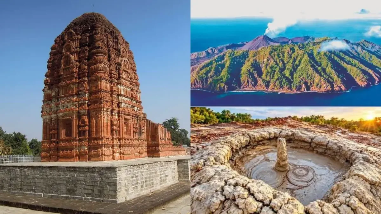
In a landmark development dominating competitive exam news today, the Permanent Delegation of India to UNESCO officially announced on October 20, 2026, that three distinct Indian heritage properties have been included in the UNESCO World Heritage Tentative List. Following formal dossier submissions prepared by the Archaeological Survey of India (ASI) on September 28, 2026, the UNESCO World Heritage Centre registered the Karst-mud-volcano Complex of Baratang (Ref. 7052) and the Andaman Subduction Volcanoes comprising Narcondam and Barren Islands (Ref. 7053) in the Andaman and Nicobar Islands under the Natural category, alongside the Sirpur Cultural and Archaeological Landscape (Ref. 7054) in Chhattisgarh's Mahasamund district under the Cultural category. With these three additions, India's cumulative inventory on the Tentative List has reached 81 properties, reinforcing its position as a premier custodian of global geological, ecological, and civilizational heritage.
For serious civil services candidates tracking current affairs October 23, 2026, this announcement represents far more than a routine diplomatic update. This Atharva Examwise current news analysis examines how the latest additions reflect a deliberate structural shift in India's heritage diplomacy. Historically, India's 45 inscribed UNESCO World Heritage Sites—most recently expanded by the inscription of the Ancient Buddhist Site of Sarnath during the 48th session of the World Heritage Committee in Busan, Republic of Korea, on July 25, 2026—have exhibited an overwhelming structural skew toward cultural monuments, comprising 37 Cultural, 7 Natural, and 1 Mixed property. By advancing two high-value island geological systems and an ancient riverine urban center built upon Proterozoic stromatolitic rock, the Ministry of Culture and the ASI are actively addressing global representation gaps in plate-boundary geomorphology, non-magmatic volcanism, island ecological succession, and early medieval urbanism. Aspirants utilizing the Atharva Examwise Current Affairs Portal for their UPSC current affairs and daily GK update will find that these three sites bridge core static concepts across Physical Geography, Environment and Ecology, and Ancient and Early Medieval Indian History.
Key Facts and Snapshot Data
Submission and Announcement Dates: Dossiers were submitted by the Permanent Delegation of India to UNESCO on September 28, 2026, and officially announced on October 20, 2026.
Newly Listed Natural Sites: Karst-mud-volcano Complex of Baratang (Ref. 7052) and Andaman Subduction Volcanoes comprising Narcondam and Barren Islands (Ref. 7053) in the Andaman and Nicobar Islands.
Newly Listed Cultural Site: Sirpur Cultural and Archaeological Landscape (Ref. 7054) on the eastern bank of the Mahanadi River in Mahasamund district, Chhattisgarh.
Updated UNESCO Tentative List Count: 81 sites across India.
Updated Inscribed World Heritage Site Count: 45 sites (37 Cultural, 7 Natural, 1 Mixed), placing India 6th globally and 2nd in the Asia-Pacific region following the July 25, 2026 inscription of the Ancient Buddhist Site of Sarnath.
Nodal Agencies: Documentation was prepared by the Archaeological Survey of India (ASI) under the Ministry of Culture, building upon the 2025 National Geo-Heritage Site designations by the Geological Survey of India (GSI).
| Property Name | UNESCO Ref. No. | State / Union Territory | Heritage Category | Nominated UNESCO Criteria | Core Geological / Cultural Significance |
|---|---|---|---|---|---|
| Karst-mud-volcano Complex of Baratang | 7052 | Andaman and Nicobar Islands | Natural | (viii), (ix), (x) | Miocene–Pliocene marine limestone karst caves (speleothems) paired with non-magmatic, fault-controlled Oligocene mud volcanoes ("Jalki"). |
| Andaman Subduction Volcanoes | 7053 | Andaman and Nicobar Islands | Natural (Serial) | (vii), (viii), (ix), (x) | Only Quaternary subduction volcanoes in the inner arc of the Burma–Andaman–Java complex; contrasts active basaltic Barren Island with dormant dacitic Narcondam Island. |
| Sirpur Cultural and Archaeological Landscape | 7054 | Chhattisgarh (Mahasamund District) | Cultural | (ii), (iv) | 5th–12th century CE Dakshina Kosala capital on the Mahanadi River; multi-faith Hindu, Buddhist, and Jain monuments utilizing Proterozoic stromatolitic limestone. |
Institutional Mechanism: UNESCO Tentative List vs. World Heritage List
A recurring conceptual trap in civil services examinations involves conflating inclusion on the UNESCO Tentative List with formal inscription on the World Heritage List. Under the 1972 UNESCO Convention Concerning the Protection of the World Cultural and Natural Heritage, which India ratified in 1977, a Tentative List functions as a mandatory national inventory of properties that a State Party considers possessing Outstanding Universal Value (OUV) and intends to nominate for formal inscription in future cycles. Operational protocols stipulate that no cultural, natural, or mixed property can be evaluated for World Heritage inscription unless it has first been registered on the nominating nation's Tentative List. Furthermore, each State Party is restricted to formally nominating only one property per year for evaluation by the World Heritage Committee, an executive body comprising representatives from 21 elected States Parties. Once a complete nomination dossier and conservation plan are submitted, independent technical bodies evaluate the property before the World Heritage Committee renders a final decision at its annual session, which has expanded the global World Heritage List to 1,273 properties across 173 countries as of the 48th session in Busan in July 2026.
The October 2026 additions represent the culmination of a rapid strategic expansion of India's heritage inventory, following immediately after five other properties were placed on the Tentative List in late September 2026. Those preceding additions included the Udaigiri Caves in Madhya Pradesh (a 4th–5th century CE Gupta rock-cut ensemble featuring 20 caves, the iconic Varaha avatar of Vishnu in Cave 5, and Anantashayana Vishnu in Cave 13), the Group of Temples of the Chambal Valley (an 8th–11th century CE cluster illustrating the evolution of regional Nagara temple architecture), Ginnorgarh Fort (a 16th–18th century Gond kingdom political center celebrated for palace murals, stepwells, and water management), Bagh Cave Paintings (nine 4th–6th century CE rock-cut Buddhist caves preserving post-Ajanta murals, notably in Cave 4), and The Sites of Satyagraha (a transnational serial nomination connecting nine Gandhian properties across India and South Africa, including Sabarmati Ashram, Mani Bhavan, Harijan Sevak Sangh, Sevagram Ashram, Aga Khan Palace, and Gandhi Smriti in India alongside Pietermaritzburg Railway Station and Phoenix Settlement in South Africa). Aspirants building their foundational concepts through the Atharva Examwise NCERT Foundation Course can observe how India is systematically curating both transnational cultural narratives and underrepresented natural landscapes for future global recognition.
Deep Dive 1: Karst-Mud-Volcano Complex of Baratang (Andaman & Nicobar Islands)
Submitted under Natural Criteria (viii), (ix), and (x) with UNESCO Reference Number 7052, the Karst-mud-volcano Complex of Baratang is situated on Baratang Island ($299.57\text{ km}^2$), part of the Great Andaman main chain located between South Andaman and Middle Andaman across the narrow Middle and Homfray straits, approximately 100 km north of the territorial capital, Sri Vijaya Puram (Port Blair). The property holds immense scientific value because it encapsulates two distinct geological phenomena—tropical marine karst caves and seismically triggered subaerial mud volcanoes—within a single outer-arc accretionary wedge.
Tectonic Origin and the Karst Cave System
Geologically, the Andaman and Nicobar archipelago forms an outer-arc, sediment-dominated accretionary wedge generated by the oblique subduction of the Indian Plate beneath the Burma microplate, representing the submerged southward continuation of the Arakan Yoma–Indo-Burman mountain ranges. The nominated karst sector spans a $1\text{ km}^2$ ($100\text{ ha}$) area in the southwestern region of Baratang Island (centered around $12.0904^\circ\text{ N}, 92.7486^\circ\text{ E}$) at elevations reaching 76 meters above sea level. Over millions of years during the Miocene to Pliocene epochs—forming the topmost stratigraphic unit of the Tertiary succession above Late Cretaceous to Late Eocene ophiolites and deep-marine sediments—marine shells, corals, and skeletal fragments accumulated and compacted into alternating strata of calcareous sandstone and siliceous limestone. Petrographically, this laminated, veil-bedded limestone consists of microcrystalline granular aggregates of calcite intermixed with grains of quartz, twinned plagioclase feldspar, and mica.
Because Baratang experiences a humid tropical monsoonal climate with heavy rainfall, chemical dissolution of these soluble carbonate "pods" embedded within a non-carbonate clay-and-shale matrix has sculpted a structurally disturbed sinkhole topography. Rather than forming continuous vertical pinnacles, differential weathering has created ribbed outcrops, deep clefts, narrow fissures, and largely inaccessible subterranean caverns adorned with speleothems—mineral deposits precipitated by percolating water in the form of stalactites and stalagmites. Beyond their geomorphic rarity, these caves act as high-resolution paleoclimatic repositories; paleoclimatologists recently utilized a speleothem extracted from the Baratang Mahadev Gupha cave to reconstruct Indian Summer Monsoon (ISM) variability across the last millennium, spanning the 10th to the 19th century CE.
Non-Magmatic Mud Volcanism ("Jalki")
Located within the Reserve Forest near Jarawa Creek in the North and Middle Andaman District ($12.1296^\circ\text{ N}, 92.792^\circ\text{ E}$), the proposed mud volcano sector covers $0.0123\text{ km}^2$ ($1.23\text{ ha}$) and is known locally as "Jalki". Within India, active subaerial mud volcanism is recorded exclusively in the Andaman Islands. Unlike true igneous volcanoes driven by molten mantle magma, Baratang's mud volcanoes are non-magmatic structures driven upward by four interconnected geological processes: the diapiric movement of buoyant, overpressured subsurface shale layers subjected to rapid terrigenous sediment loading; rapid subsidence and lateral tectonic compression along the convergent plate boundary; deep subsurface hydrocarbon generation; and the upward expulsion of pressurized fluids along deep-seated fault and fracture zones trending predominantly Northeast–Southwest.
The Baratang mud volcano complex consists of four active vent clusters that form low mud cones rising approximately 2 meters high at their centers, surrounded by bubbling pools and dried, fissured crater fields. Following two decades of dormancy, the mud volcanoes erupted again in 2025, the same year the Geological Survey of India (GSI) designated the complex a National Geo-Heritage Site. The extruded slurry is cool—recording surface temperatures between $29.39^\circ\text{C}$ and $30.07^\circ\text{C}$—and weakly alkaline ($\text{pH } 8.0\text{ to }8.3$), emitting mud, water, methane ($\text{CH}_4$), and hydrogen sulphide ($\text{H}_2\text{S}$) alongside sandstone and shale rock fragments (lithoclasts) originating from the Oligocene-era Mithakhari Group (34–23 million years ago). Because subsurface gas emissions respond sensitively to crustal stress, the site serves as an active research station for earthquake prediction through gas-geochemical monitoring.
Subterranean Ecology and Global Comparative Context
Ecologically, the Baratang complex links tropical evergreen and semi-evergreen rainforests, coastal mangroves, and subterranean cave microhabitats within the Indo-Burma Biodiversity Hotspot. Cave entrances and twilight zones support cryptogamic flora including algae, mosses, and liverworts alongside penetrating rainforest root systems, whereas the dark cave interiors provide nesting habitats for the endemic Andaman Edible-nest Swiftlet, the Andaman Horseshoe Bat, Homfray's Horseshoe Bat, and specialized cave-adapted arthropods (spiders and cave crickets) and isopods. In UNESCO's global comparative assessment, Baratang fills a critical regional gap in South Asian karst representation: whereas Madagascar's Andrefana Dry Forests (Tsingy de Bemaraha) feature 100-meter-high Mid-Jurassic pinnacle karst shaped by a pronounced dry season, and Azerbaijan's Lok-Batan Mud Cone exhibits violent, self-igniting eruptions from young Pliocene deposits (3–5 million years old), Baratang uniquely combines humid tropical pod-karst caves with gentle, non-igniting Oligocene mud volcanism.
Deep Dive 2: Andaman Subduction Volcanoes – Barren and Narcondam Islands
Registered under UNESCO Reference Number 7053 across all four Natural Criteria—(vii), (viii), (ix), and (x)—the Andaman Subduction Volcanoes serial nomination encompasses Barren Island and Narcondam Island in the Andaman Sea, situated approximately 1,200 km from the Indian mainland. Positioned near the northern end of the Sunda Arc within the 5,000 km-long Burma (Myanmar)–Andaman–Java subduction complex, these two islands constitute the only Quaternary-period (the last ~2.6 million years) subduction volcanoes in the inner volcanic arc chain. Their formal inscription would establish the first volcanic island World Heritage Site in the South Asian region.
Crustal Architecture and Petrological Divergence
A critical analytical dimension for UPSC current affairs lies in understanding why Barren Island and Narcondam Island exhibit fundamentally different volcanic morphologies and rock compositions despite belonging to the same subduction arc. Barren Island ($8.34\text{ km}^2$, located 138 km northeast of Sri Vijaya Puram) sits directly above oceanic lithosphere where partial melting occurs at depths of 17 to 27 km, generating low-viscosity mafic lavas dominated by basalt and basaltic-andesite. Rising to an elevation of 354 meters above sea level from a submarine base plunging 1,000 to 1,500 meters deep, Barren Island represents the remnant of a late-to-post-Pleistocene stratovolcano that originally exceeded 600 meters in height before a catastrophic explosive collapse created a 2 km-wide caldera breached toward the northwest.
In contrast, Narcondam Island ($6.8\text{ km}^2$, situated 240 km northeast of Sri Vijaya Puram and deriving its name from "Naraka-Kundam", meaning "a pit of hell") is positioned closer to the Asian continental margin above continental-to-transitional crust. Consequently, ascending mantle magmas beneath Narcondam undergo significant magma mixing with crustal material, producing more viscous, calc-alkaline rocks consisting of dacite, andesite, and rhyolite—specifically dacitic lava at the central summit and andesitic to amphibole-andesite lava along the base and northeastern margin. Rising precipitously to 710 meters above sea level without a summit crater, Narcondam displays a triple-peaked crown formed by three volcanic hummocks alongside clear geomorphic signatures of recent tectonic uplift, including hanging valleys with radial drainage and vertical coastal cliffs.
Eruption Timeline and Complementary Ecological Succession
Together, the two uninhabited islands function as complementary natural laboratories demonstrating contrasting stages of island colonization and ecological succession. Barren Island—South Asia's only historically active volcano, protected as the Barren Island Wildlife Sanctuary and declared a GSI Geo-Heritage Site in 2025—has recorded major eruptions since 1787, followed by 150 years of dormancy before erupting in 1991, 1994–95, and 2005–07 (the latter potentially triggered by the 2004 Indian Ocean earthquake). Subsequent activity includes mild eruptions in 2008–2010, ash emissions in 2017, gas and ash releases in 2022, two mild eruptions in September 2025, and an ash plume rising 1.2 km (4,000 ft) accompanied by a summit thermal anomaly on January 10, 2026. Because recurring lava flows and ash fallout periodically sterilize the surface, Barren Island exhibits repeated primary ecological succession, wherein pioneer species such as lichens and bryophytes continually re-establish soil and vegetation, while an isolated population of feral goats left by British sailors in 1891 has adapted to survive on sparse scrub and freshwater springs. Beneath the waves, its steep volcanic walls are colonized by vibrant coral reefs and sponges in crystal-clear waters.
| Parameter | Barren Island (Southern Component) | Narcondam Island (Northern Component) |
|---|---|---|
| Volcanic Status | Active (South Asia's only confirmed active volcano). | Dormant / Extinct (Dormant for ~18,000–20,000 years). |
| Recorded Eruption Timeline | First recorded in 1787; major eruptions in 1991, 1994–95, 2005–07; recent activity in 2017, 2022, Sept 2025, and a 1.2 km ash plume on Jan 10, 2026. | No Holocene historical eruptions; three summit hummocks represent remnants of Pleistocene domes. |
| Crustal Setting & Rock Type | Oceanic crust (melting at 17–27 km depth); Basalt and Basaltic-Andesite lavas. | Continental-to-transitional crust; Calc-alkaline Dacite, Andesite, and Rhyolite (magma mixing). |
| Topography & Elevation | $8.34\text{ km}^2$ area; 354 m peak; 2 km-wide caldera breached to the northwest. | $6.8\text{ km}^2$ area; 710 m triple-peaked summit; hanging valleys, no summit crater. |
| Ecological Succession Stage | Repeated Primary Succession: Recurring lava and ash flows reset pioneer colonization. | Mature Climax Community: Uninterrupted tropical forest evolution over 18,000–20,000 years. |
| Key Fauna & Conservation | Barren Island Wildlife Sanctuary & GSI Geo-Heritage Site (2025); adapted feral goats (introduced 1891); submarine coral-sponge walls. | Important Bird Area (IBA) & Key Biodiversity Area (KBA); endemic Narcondam Hornbill (Rhyticeros narcondami) and Narcondam Shrew (Crocidura narcondamica). |
Conversely, Narcondam Island has remained dormant for an estimated 18,000 to 20,000 years, allowing primary volcanic succession to progress uninterrupted into a dense, mature climax tropical forest community. Free from civilian settlement and closed to tourism—housing only a small police check post of roughly 20 personnel established in 1968—Narcondam is designated as an Important Bird Area (by BirdLife International and the Bombay Natural History Society) and a Key Biodiversity Area. This extreme isolation has fostered point-endemism, most notably the Narcondam shrew (Crocidura narcondamica) and the Narcondam hornbill (Rhyticeros narcondami), which is classified as Vulnerable on the IUCN Red List and protected under Schedule I of India's Wild Life Protection Act. Following the removal of introduced feral goats that previously suppressed food-tree sapling regeneration, alongside strict anti-hunting enforcement, the Narcondam hornbill population recovered to densities exceeding 150 birds per $\text{km}^2$ by 2010.
Deep Dive 3: Sirpur Cultural and Archaeological Landscape (Chhattisgarh)
Submitted under Cultural Criteria (ii) and (iv) with UNESCO Reference Number 7054, the Sirpur Cultural and Archaeological Landscape is situated on the eastern bank of the Mahanadi River in Chhattisgarh's Mahasamund district, roughly 78 km from the state capital, Raipur ($21^\circ 20'47.56''\text{ N}, 82^\circ 10'55.38''\text{ E}$). Known in ancient epigraphs as Shripur or Sripura ("City of Wealth/Auspiciousness"), Sirpur represents an exceptional early medieval inland riverine capital where royal patronage, commercial trade routes, and multi-religious architecture converged between the 5th and 12th centuries CE. Aspirants preparing for state civil services via the Atharva Examwise MPPSC & State PCS Portal will find Sirpur central to the historical and cultural geography of the Chhattisgarh basin.
Geological Foundation: Billion-Year-Old Stromatolites as Building Stone
A remarkable interdisciplinary aspect highlighted in Sirpur's UNESCO dossier is the geological foundation of its cultural landscape. Sirpur lies within the Proterozoic Chhattisgarh Basin, shaped extensively by the Raipur Limestone Group. The local terrain contains abundant stromatolites—fossilized, laminated calcareous sedimentary structures formed over one billion years ago by the metabolic and sediment-trapping activities of photosynthetic cyanobacteria. Ancient artisans and engineers in Sirpur quarried these calcified, richly textured stromatolitic rocks directly from the local basin to construct temple foundations, plinths, and structural walls, establishing a tangible link between Precambrian geobiology and early medieval Indian architecture.
Dynastic Evolution, Hiuen Tsang's Account, and ASI Excavations
Historically, Sirpur emerged as the capital of the Dakshina Kosala kingdom (distinct from the Uttara Kosala kingdom of the Gangetic plain centered at Ayodhya and Shravasti) under the Sharabhapuriya dynasty, with the oldest occupational layer dated to the last quarter of the 5th century CE via a gold coin of the Sharabhapuriya ruler Prasannamatra. The city subsequently reached its architectural and political zenith as the capital of the Panduvamshi (later Somavamshi) dynasty, particularly during the 60-year reign of Mahashivagupta Balarjuna (dated c. 595–655 CE, or to the early 8th century CE in M.G. Dikshit's 1954–55 excavation chronology), while later coins of the Kalachuri king Ratnadeva confirm continued medieval trade.
During the 7th century CE, the Chinese Buddhist pilgrim Hiuen Tsang (Xuanzang) visited Dakshina Kosala and recorded its flourishing Buddhist monasteries, large monastic population, and scholarly vitality. Epigraphic inscriptions of Mahashivagupta Balarjuna at the Gandheshwar Temple further confirm that Sirpur functioned as a prosperous inland port along the Mahanadi River trade corridor. Following its medieval decline after Nala invasions, the ruins were first surveyed in the 19th century by J.D. Beglar and rediscovered in 1882 by Alexander Cunningham, the first Director-General of the ASI. Major excavations conducted in the 1950s, 1990s, and between 2000 and 2004 unearthed 22 Shiva temples, 5 Vishnu temples, 10 Buddhist viharas, and 3 Jain viharas, alongside a 7th–8th century metal sculpture workshop whose bronze icons have been exhibited internationally in England, Germany, and the United States.
Urban Layout, Monumental Architecture, and Multi-Faith Pluralism
Rather than representing an isolated religious precinct, Sirpur preserves an integrated early medieval urban plan extending across a 6.5 km stretch of the Mahanadi riverbank. The municipal infrastructure encompassed broad streets, sophisticated subterranean drainage networks, a 6th-century Market Complex equipped with a watchtower at the main road intersection, courtyard-centered palaces, residential quarters, granaries, freshwater wells, and a public bath used for Ayurvedic treatments. Spatially, the archaeological core is organized across five directional zones: a Vishnu temple complex with a school and a Shiva temple on the Eastern Edge; two priests' houses and a Shiva temple on the Southern Edge; the Rajmahal palatial complex and Gandheshwar Temple on the Western Edge along the Mahanadi; a pancharatha Shiva temple on the Northern Edge; and the Bateshwar (Baleshwar) Group of Monuments at the Center. Within the core area, UNESCO lists nine specific nominated structures: the Laxman (Lakshmana) Temple, Ram Temple, Gandheshwar Temple, Anandprabhu Kuti Vihara, Swastik Vihara, Market Complex, Rajmahal, Harshagupta and Teevardeo (Tivaradeva) Buddha Vihara, and the Baleshwar Group of Monuments.
Among these structures, the 7th-century CE Lakshmana Temple stands as one of India's finest surviving examples of early medieval fired-brick Nagara architecture. Raised on a high stone platform (jagati) accessed via northern and southern steps, the temple comprises an oblong stone-pillared mandapa (noted by Cunningham for departing from standard square northern plans), an antarala, and a garbhagriha surmounted by a 5-tiered curved brick shikhara crowned with an amalaka, representing the earliest known fully staggered square plan in India. Historically, the temple exemplifies royal religious pluralism: although the Panduvamshi rulers were devout Shaivites, this Vaishnavite shrine dedicated to Lord Vishnu was commissioned around 625–650 CE by Queen Mother Vasata—daughter of the Maukhari King Suryavarman of Magadha—in memory of her late husband King Harshagupta during the reign of their son Mahashivagupta Balarjuna. While the main superstructure is constructed of precision-molded, carved bricks, stone was used selectively for the ornate sanctum doorframe, which depicts Anantashayana (Sheshashayi) Vishnu reclining on the cosmic serpent Sheshnag with Brahma seated on a navel-lotus, accompanied by Dashavatara incarnations, Krishna Leela panels, and Ganga–Yamuna river goddesses.
Complementing the brick Vishnu shrine is the Surang Tila complex, excavated in 2005–2006, which rises on a towering white-stone terrace accessed by 37 steep steps leading to a 32-pillared mahamandapa built in the panchayatana style; its five sanctums house four Shiva Lingas in the eastern and northern chambers and an idol of Ganapati in the southern chamber. Adjacent to these Brahmanical shrines lie the multi-cellular Buddhist monasteries—Anandprabhu Kuti Vihara, Swastik Vihara, and Tivaradeva Mahavihara—which feature open courtyards, water storage systems, meditation halls, and colossal seated Buddha statues. Surrounding this monumental core, Sirpur's buffer zone encompasses a living village of approximately 300 houses (~1,500 residents), indigenous Gond and Baiga tribal communities—whose cultural preservation aligns with themes explored in Atharva Examwise's analysis of tribal livelihoods—and the ecologically rich Barnawapara Wildlife Sanctuary. In UNESCO's comparative framework, Sirpur bridges the gap between international maritime emporiums like Quanzhou (China) and political capitals like Polonnaruwa (Sri Lanka) by preserving an inland riverine capital shaped by multi-faith patronage.
Why this matters for your exam preparation
For aspirants preparing for the UPSC Civil Services Examination (Prelims and Mains), State PSCs (especially MPPSC and CGPSC), and other competitive examinations, this daily GK update intersects directly with high-probability themes across General Studies Papers I and III. Candidates enrolled in the Atharva Examwise UPSC Live Foundation Batch and utilizing Atharva Examwise Study Material, Mind Maps, and PYQs can leverage the following synthesis to maximize their score.
Multi-Disciplinary Syllabus Integration
In UPSC Mains GS Paper I (Art and Culture), Sirpur serves as an ideal case study illustrating how early medieval regional kingdoms fostered simultaneous patronage of Shaivism, Vaishnavism, Buddhism, and Jainism while pioneering regional Nagara brick architecture and bronze casting alongside riverine urbanism. This architectural synthesis can be studied alongside other regional temple traditions covered on the Atharva Examwise platform, such as Kateel Sri Durgaparameshwari Temple and Yakshagana Heritage. In GS Paper I (Physical Geography), the two Andaman nominations provide textbook examples of Indo-Burman plate subduction, contrasting outer-arc accretionary sediment wedges (Baratang's Miocene–Pliocene marine karst caves and fault-controlled Oligocene mud diapirs) with inner-arc Quaternary magmatic volcanism (Barren Island's oceanic basaltic caldera versus Narcondam's continental-transitional dacite-andesite dome), while Sirpur links cultural heritage to Proterozoic stromatolitic geology. In GS Paper III (Environment, Biodiversity, and Disaster Management), Barren and Narcondam Islands offer a pristine comparative model of disturbance-driven primary succession versus 20,000-year climax forest succession, invasive species eradication (feral goats), island point-endemism, and geochemical earthquake forecasting.
Exam-Relevant Data and Prelims Fact Sheet
India's UNESCO Portfolio (October 2026): 45 Inscribed World Heritage Sites (37 Cultural, 7 Natural, 1 Mixed — Khangchendzonga National Park, Sikkim) and 81 Tentative List Sites.
Recent Inscribed Additions: 45th — Ancient Buddhist Site of Sarnath, Uttar Pradesh (July 25, 2026, 48th WHC Session, Busan, under Criteria iii and vi; includes Dhamekh Stupa, Dharmarajika Stupa, Chaukhandi Stupa, Mulagandhakuti Vihara, and Ashokan Pillar); 44th — Maratha Military Landscapes of India (2025); 43rd — Moidams of the Ahom Dynasty, Assam (2024).
First Inscribed Sites in India (1983): Ajanta Caves, Ellora Caves, Agra Fort, and Taj Mahal.
Baratang Mud Volcano ("Jalki") Facts: Non-magmatic; driven by overpressured shale diapirism; emits cool ($29.39^\circ\text{C}\text{–}30.07^\circ\text{C}$), weakly alkaline ($\text{pH } 8.0\text{–}8.3$) mud, water, methane ($\text{CH}_4$), and hydrogen sulphide ($\text{H}_2\text{S}$) with Oligocene Mithakhari Group lithoclasts; erupted in 2025 after 20 years of dormancy.
Baratang Karst Cave Facts: Miocene–Pliocene calcareous sandstone and siliceous limestone; hosts endemic Andaman Edible-nest Swiftlet and Horseshoe Bats; Mahadev Gupha speleothem reconstructed 10th–19th century CE Indian Summer Monsoon variability.
Barren vs. Narcondam Facts: Barren Island ($8.34\text{ km}^2$, 354 m peak, oceanic crust, basaltic lava, 2 km caldera, active in Sept 2025 and Jan 10, 2026 with a 1.2 km ash plume, primary succession) vs. Narcondam Island ($6.8\text{ km}^2$, 710 m peak, continental-transitional crust, dacite-andesite-rhyolite lava, dormant 18,000–20,000 years, climax forest, endemic Vulnerable/Schedule I Narcondam Hornbill Rhyticeros narcondami and Narcondam Shrew Crocidura narcondamica).
Sirpur Key Facts: Capital of Dakshina Kosala (Sharabhapuriya King Prasannamatra 5th century gold coin; Panduvamshi King Mahashivagupta Balarjuna 7th century peak); visited by Hiuen Tsang; rediscovered by Alexander Cunningham in 1882; built using >1-billion-year-old Proterozoic stromatolites (Raipur Limestone Group); features 7th-century brick Lakshmana Temple (dedicated to Lord Vishnu, built by Queen Vasata, daughter of Maukhari King Suryavarman of Magadha and widow of Harshagupta) and panchayatana Surang Tila; buffer zone includes Gond and Baiga tribes and Barnawapara Wildlife Sanctuary.
To practice daily Prelims MCQs, download structured revision mind maps, and attend interactive live classes, explore the Atharva Examwise Courses Catalog or register for a Free Demo Class on Atharva Examwise.